Winter weather has been generally a no-show across Wisconsin to this point this season. Today it gets here, and it arrives with all the subtlety of Cousin Eddie showing up at the Griswold's in "Christmas Vacation."
Yet, to be clear, the storm will not have a major impact on the city of Milwaukee and adjacent communities. Yes, there will be snow. Plus, it will be brutally windy by Thursday afternoon and evening. But the snow accumulation and its on impact on travel in the city of Milwaukee will be nothing compared to what will happen in southwest, central and northeast Wisconsin.
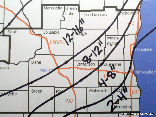
Milwaukee will likely have rain into the afternoon before it finally turns to snow. The heaviest snow is expected in Milwaukee between 3 and 8 p.m. It will total 2 to 4 inches by the time it ends. A few locations in far western and northwestern Milwaukee County may exceed 4 inches by a bit (Brown Deer, Wauwatosa, West Alllis).
I also expect a day of mainly rain in Racine and Kenosha counties with an eventual changeover to snow and 2 to 4 inches of accumulation.
Waukesha and Ozaukee counties will be in for a rougher go of it. Those counties will have a mix of rain and snow Thursday morning before the precipitation becomes all snow in the afternoon. Total snow accumulations in those counties will range from 4 to 8 inches. Totals at the low end of that range will be most common in the eastern and southeastern portions of the counties (Mequon, Thiensville, New Berlin, Muskego), and totals at the high end of that range most common in the west and northwest
(Oconomowoc, Hartland, Delafield).
Further west, a paralyzing blizzard will rage most of the day. Snow totals will exceed a foot in a wide swath from the southwest corner of Wisconsin all the way to Green Bay.
This includes cities such as Madison, Beaver Dam, Fond du Lac, and Wisconsin Dells.
The heavy snow will be accompanied by winds of 35-45 miles per hour, with the possibility of some gusts over 50 miles per hour. It is in this part of Wisconsin where many roads will become impassable. Visibility will frequently be reduced to zero and white-out conditions will continue through Thursday night.
In fact, all of Wisconsin will experience brutally strong winds Thursday afternoon and night. I'd recommend you take precautions to secure your Christmas decorations or they will be leaving.
Also on the table are power outages due to the combination of snow and wind.
Thunder and lightning are also a reasonable bet during the height of the storm. In simplest terms, this is simply an indication of just how powerful this weather system is.
It's taken a while, but winter 2012-13 appears to finally be cranking up. And like Cousin Eddie, it's likely to hang around for a while.
Craig is a meteorologist who was born and raised in Pewaukee. After getting a degree in Meteorology from the University of Wisconsin-Madison, he worked over 20 years on TV and radio in Milwaukee, Madison, Omaha, Nebraska and Kansas City, Missouri.
Craig spends most of his time trying to keep up with his bride and their three teenage daughters. Any time left over is spent with his other beloveds, the Packers, Brewers and Badgers.


